(22,822 statute miles ; 36,729 km)
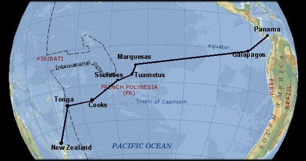
Since leaving Panama early in March we have sailed 6700nm across the Pacific to the charming Kingdom of Tonga. It has been a splendid voyage, memorable not only for the many exotic and beautiful places we have visited but also for the superb trade wind sailing and opportunity to discover Polynesian culture in its many guises, across millions of square miles of this vast ocean. We have come to love the Pacific and its peoples in a way we never imagined was possible. So, it looks as though our premonition has been transformed to fact and we are going to remain in these parts for a number of years.
At dawn on Saturday May 4th, 18 days out from the Galapagos after a splendid 3000 mile crossing characterised by consistent E/SE winds, we sighted Fatu Hiva in French Polynesia. This is an islet 8 miles long with 3000ft peaks at each end and a cleft between ending at the somewhat windy anchorage below. This was just a portent of the magnificently dramatic scenery we were to enjoy for nearly a month in this archipelago of high volcanic islands, rich in rock pillars and verdant tropical growth right down to the shoreline.
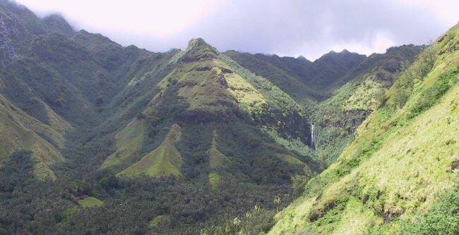
Naturally enough, after a night's rest we were keen to get ashore to meet the locals, stretch our legs and explore this tantalizing scenery. Eight of us set off, with the 150m high waterfall you can see almost lost in the green mountain sides below, as our objective. The going was quite tough on the final approach through steep, dense forest but the swim in the large pool at its base more than compensated. We also discovered that the people of the island are well cared for with grants from France and the EU but have no airstrip and are not well served by visiting ships. This has led to a shortage of all but essential goods which meant we were constantly under pressure to supply luxuries as gifts or by barter.
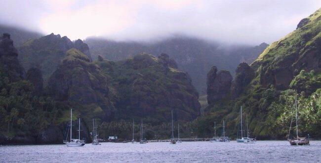
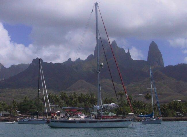
There are around twelve Marquesan islands, six of which support small populations. Their problem as far as sailors are concerned is finding an anchorage sheltered from the large swells prevalent in the Pacific. These are geologically 'young' islands so have not developed the coral fringing reefs of the Society Islands or been reduced to atolls like the Tuamotus that we were to visit later. After calling in at the small island of Tahu Ata we anchored beneath these towering pinnacles at the charming port of Hakahau on the island of Ua Pou. It was here and at the nearby bay at Hakahetau that we began to appreciate the strong and distinctive culture of the Polynesian Peoples and to admire the way they have managed to protect so many aspects of it from outside influences. This was in stark contrast to what we had seen in the Caribbean.
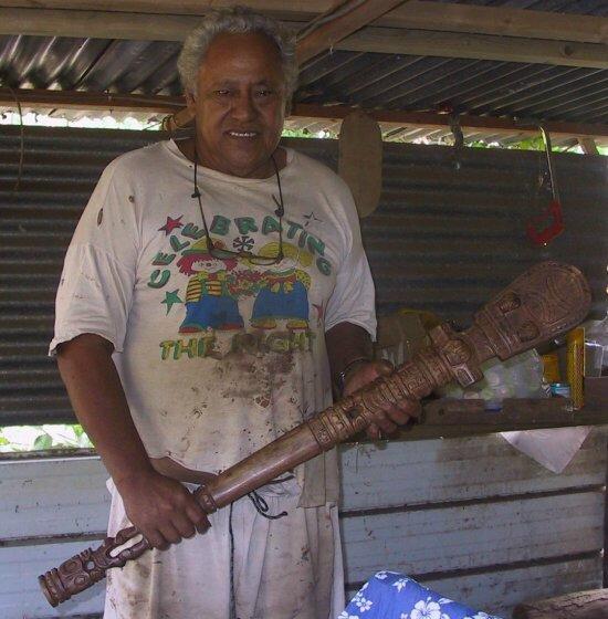
When we began our voyage we had expected our floating home to become laden with collectable items that we felt we just had to take back as souvenirs of our trip. Amazingly we had surprisingly few and almost all from Andean South America rather than the Caribbean Isles. However the prowess of the Polynesian carvers has changed all that and we now have a fair number of decorative and utilitarian pieces bought directly from the craftsman in their back yards. Here is Tui from Hakahau holding the casse-tete (traditional 'head breaking' club) which is now mounted above our bunk in the aft cabin (intruders beware!). He's a lovely guy who delighted in conversation on any topic (in French) and sent us away with a letter of introduction to his son on Nuku Hiva with a request to stock us up with fruit and veg.
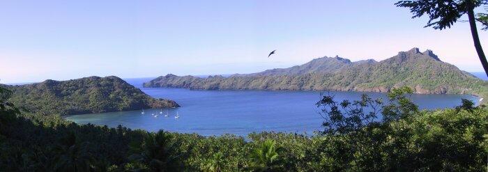
Our next stop was at the main island, Nuku Hiva which boasted a number of large, deeply inset bays with the prospect of some excellent walking. Three of these proved exceptional with dramatic scenery and walking into the interior to die for. The one below is Anaho on the north coast which numerous circumnavigators have quoted as one of the best anchorages in the world. We were a week there and would be happy to concur. Another favourite was Controller Bay where we walked for 8hrs one Sunday, much of the time searching out maraes, ancient stone ritual sacrifice sites surrounded by tikis. In the south west of the island is the amazing Daniel's Bay with a walk up a very long closed valley to a waterfall. This starts on a stone lined pathway over 450yrs old and culminates in the usual scramble over rocks and through rivers, waist deep in fast flowing water. This bay also had the dubious distinction of being the site chosen for the filming of the '02 episode of the US TV programme, Survivors. At least Daniel got a new home out of it.
After a pretty active month in the Marquesas it was time to move on to the Tuamotus, low atolls which spread for 1000 miles across the route to Tahiti. Before the advent of GPS navigation this was known as the Dangerous Archipelago as there is little to warn the mariner of approaching reefs. It gained some notoriety as one of the southerly atolls of the group is Mururoa where the French carried out nuclear weapon testing.
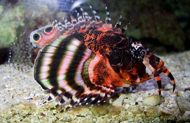
Our landfall was Makemo, a large 40 x 10 mile atoll with one small village and a reef strewn interior that made moving around impossible except with a high sun and someone dedicated to rock spotting. The attraction here was the superb, crystal clear water and abundance of fish. The waters of the Marquesas had been a little murky and as there were also a lot of sharks around it was not a good idea to be in with them without being able to monitor the specie and their intentions. Sharks were here in abundance too but at least one could see them. The other feature of this atoll was the absence of cigatura, the poison that fish concentrate by feeding on contaminated coral reef algae. This was an enormous plus as marine life was so plentiful that fishing with the speargun was almost like going to Sainsbury's fish counter. Our favourites were grouper, snapper and tuna. This could also be augmented by scuba diving for scallops on the deeper coral reefs.
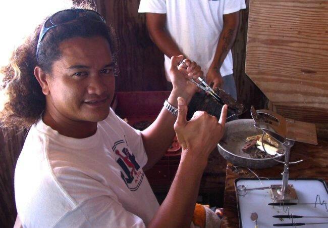
The people of the village were the most friendly we have ever met and we were constantly invited into homes and engaged in long conversations. Again they are quite well off for an isolated community with very little to do other than collect coconuts for copra, fish or cultivate pearls. There was a small pearl operation based in someone's back yard where they were only too happy to show us the intricate process of seeding the oyster with a plastic bead and to sell us some of the product.
We had intended to call at several other atolls but we were so enchanted with the marine life of Makemo that we chose instead to move around to four sites scattered along the 40 miles within the atoll. The lack of cigatura which is pretty rife in this region was a further deterrent to moving on. We would spend hours each day snorkelling and diving amonst coral heads observing and photographing the most amazing fish. Di even became relatively tolerant of the many sharks that accompanied us on every trip. These were mainly black tipped reef sharks between 3-5ft long. They were inquisitive but would disappear if confronted, except that is when one had a fish on the spear. Then they would charge and buffet to get at it but luckily they never took a bite. Here is one of the more exotic fish that Dave managed to picture.
After close to a month of the simple life on an atoll we were almost prepared for the contrast of the big city of Papeete on Tahiti which is the hub of French Polynesia and home to about 85% of the population. The island is crowded and busy but one is everywhere aware of the wonderful scenery, exotic flowers and alluring fragrances. A very modern version of paradise.
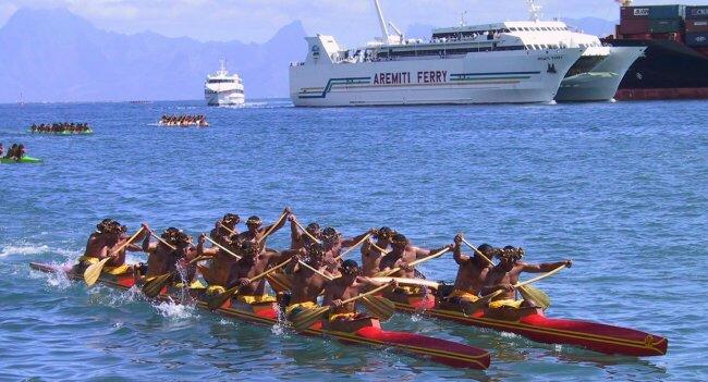
Our stay coincided with the annual Heiva festival of Polynesian culture which in addition to colourful displays of grass skirted dance and song, also featured nearly two weeks of canoe racing. The traditional outrigger canoe is also a powerful cultural symbol, so that each evening and weekend where ever we were in the region we were hailed by crews out practising around our anchorages.
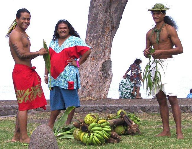
The festival was a superb opportunity to further our knowledge of the people and experience the splendours of traditional song and dance. Attending a church service to listen to the congregation in full voice was especially moving. In addition to these modern insights we re-read Richard Hough's excellent biography of Capt James Cook with all the history of the first landings and contacts with the peoples of these charming islands. Below are some guys preparing for a traditional race with a fruit laden pole, that Di insisted she needed to have a photograph of (she misses her boys!).
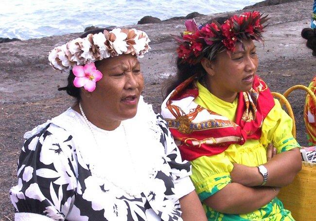
These two ladies below have just finished singing in a small choir of Mamas and are casting a critical eye and ear over the next contestants. Flowers are another strong Polynesian symbol used not just for special occasions but as a daily adornment tucked in beside the ear or arranged on the counter of the shop or bank. Visitors arriving in the islands are given a lei (necklace of flowers) which if cast on the waters as you leave will ensure you will return. Fortunately the supply of blooms is inexhaustible so even cruisers find blossoms falling from the trees everywhere to practice with.
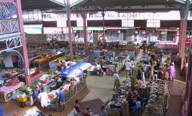
This abundance of nature's bounty does not always work in our favour though. Most fruit like the huge pampelmouse (sweet & juicy green grapefruit up to 25cm diam), mangos, papaya (pawpaw) and bananas grow like weeds in peoples gardens so shops do not usually stock them. On some islands we found them growing wild in the forests so could stock up with a supply to last several weeks. Below is the public market in Papeete which did sell some fruit and veg but was principally a vast emporium of craft and local art goods.
Whilst in Tahiti we discovered it was one of only two places that had a regular air connection to Easter Island. So, almost without thinking about it, we booked to have four days there and started trying to recollect all we knew about that mystical island. By Boeing 767 it is a 5hr, 4000km flight with a 4hr time difference, an illustration if ever one were needed to the vastness of the Pacific Ocean. On arrival we were of course keen to check out all those notoriously dangerous anchorages where sudden wind shifts have caught out many a sailor. July is mid winter in the Southern Ocean so we were not disappointed to find that though we might have been able to sail there, the swells were immense and chances of anchoring anywhere safely looked extremely slim.
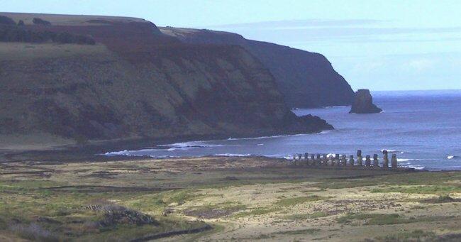
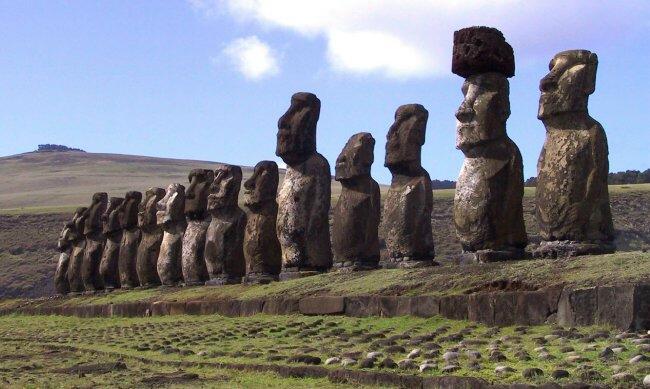
It is a wonderful place, preserved as a heritage site for those huge, tantalizing stone statues and the cultural history associated with them. The population of around 3500 all live in one village on the SE end, leaving the remainder of the 6km triangular island an unspoiled treasure house to be explored on foot, by bike or 4 wheel drive vehicle. Below is one of the most impressive statue groups, looking inland over the site of what was an ancient settlement.
This offshoot Polynesian society had been a divided one with a ruling class that did virtually no work and an underclass who toiled not only to support there chiefs but also to carve, transport and raise these huge edifices. All the figures were carved high in a volcano at the Rano Raraku quarry in the west of the island, which still has 260 in various stages of completion. Most of the figures are over 10m high, weighing around 50 tones so transportation across the island's rough and often soft terrain presented a significant logistical problem.
Their purpose was to subjugate the populace by arranging effigies of their dead chiefs to overlook the sites of the settlements. The remains of their dead rulers were dried and placed beneath the statue. Once in place the eyes of white coral rock with pupils made of black obsidian, a volcanic crystal, were installed so that the mana (spiritual power) of the dead could be beamed out, so to intimated their people into subservience. About 250 years ago, around the time the chiefs were going for enhanced sized statues of around 15m in length, there was a civil war and insurrection with the overturning of many of the edifices. To this day there are still signs of these divisions in Easter Island society.
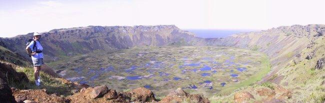
Whilst we were there we were blessed with good weather so had four full days of walking and exploring. One of the most impressive sites was a volcano filled with water (Rano in the Rapa Nui language). The pool of clear water within was 1km in diameter and over 280m deep. The surface is composed of exuberant growth with bulrushes, capable of supporting you should you wish to risk it. Our short stay on this most fascinating of Chilean islands was not only packed with wonderful experiences but a chance to make many new friends from a wide spectrum of backgrounds.
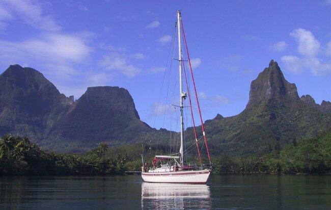
Back in Tahiti our other life afloat awaited us, so after a flurry of provisioning we headed out for the magical Society Islands to the west, known as the Leewards. First was Moorea, a near neighbour just 10nm from Papeete. We chose the quieter of the two bays on the north side where we lay in the tranquil waters of what had been the crater of a volcano with a backdrop of peaks literally out of the movies. The story of the musical South Pacific was based on the US occupation of Bora Bora shortly after Pearl Harbour but it was filmed here in Opunoho Bay on Moorea. The pointed peak to the right you may remember was renamed Bali Hai in the movie. These islands have good roads and are much quieter so out came the mountain bikes for more extended exploration.
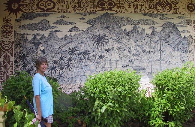
Capt Cook was fond of this bay and the nearby town of Papetoai became a focus for settlers and missionaries. The protestant church there is said to be the oldest in the islands. Here's Di standing by a mural in the town illustrating its founding as a settlement.
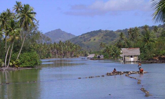
Our next destination Huahine was an overnight passage of 90nm. It was again a beautiful spot with high mountains and an all enclosing, fringing reef complete with a navigable channel down the west side. We walked for miles in the hills and exploring the many archeological sites in the north of the island. Below is an ancient fish trap formed from stones placed at a shallow point inside the reef. As with all these islands you can find numerous fabulous anchorages with crystal clear water so it becomes difficult to drag yourself away on the westward trek.
On past Raiatea and Taaha we came to the fabled isle of Bora Bora with its three high peaks and symmetrical fringing reef. We had fallen in love with the place four years ago when we first opened out the chart on the loft room floor, so arriving there was a special occasion. In readiness we had bought the soundtrack CD of South Pacific so stormed through the single pass on the NW side with all four speakers blaring. Dinner at Bloody Mary's a couple of nights later was of course essential after that entry. The romantic theme was continued next day when we celebrated our 37th wedding anniversary in the yacht club there with twelve sailing friends.
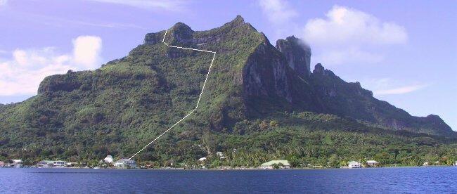
Dave managed to rally enough support to scale the 618m (2025ft) peak in what turned out to be a very tough scramble up very difficult and sometimes slippery terrain. Fortunately we took a climbing rope which proved essential, particularly on the descent. The approximate route up to the summit ridge through the thick vegetation is marked by the white line. In all it took us nearly eight hours so you can imagine what amused looks the ten or so weary and very dirty yachties got from the locals as we emerged from the woods into the village.
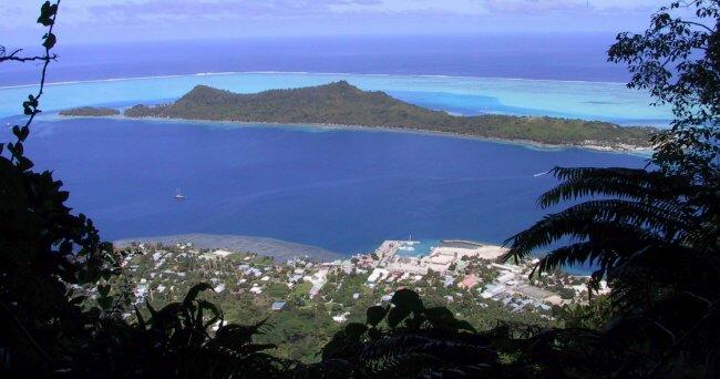
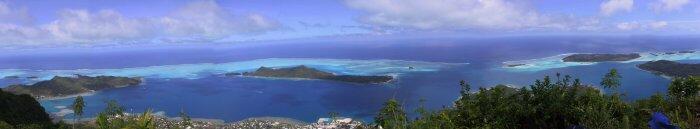
No matter how fatigued we were, nothing could diminish the superb vistas right around the reef. Above we looked down on the town with the largest island within the reef in the background. Below is a 180° view taken by electronically 'stitching' a number of pictures together. This technology is great but displaying these long thin images presents problems unless you want to produce something like decorative toilet paper. The single, narrow pass in through the reef can be discerned about two thirds the way across the picture below on the right.
From Bora Bora we were into serious passage making again through the Cook Islands to Tonga. We took a southerly route via the lovely, laid back island of Rarotonga which is a self governing territory of New Zealand. We had a very enjoyable week there, hired a motor scooter to explore and did some spectacular ridge walking, crossing the island over the mountain route.
We broke the next 1000 mile next by calling in at Beveridge Reef which must be one of the most amazing anchorages anywhere. The sea is around 5000m (over a mile) deep for hundreds of miles around but this 5mile diameter volcano peak lies just below the surface with a submerged coral reef and shallow entry pass. The only 'landmark' around is the wreck of a 90ft Seattle fishing boat that would seem to have been there for 20 years. The visibility underwater was over 50m and marine life superb. Again the speargun fed us but the sharks were very active with typically at least four arriving before Dave could hold the fish out of the water. Di was not best pleased having to deliver a large bucket to him with sharks circling between us!
We arrived in the Kingdom of Tonga on 20th Sept having completely lost Thursday the 19th as we crossed the International Date Line on the way in. Our clocks having lagged behind our friends and family in Europe for three years, it now seems strange to find ourselves 12 hour ahead for a change.
We will endeavour to complete the story from French Polynesia, through the Cooks and Tonga when we reach New Zealand in November. We can't wait to arrive for we have lots of visitors from home joining us. Younger son Paul with his fiancee Emma should be around to greet us. Bruce and Tracey are next and then Di's Mum will be there to spend Christmas and New Year with us. We are also looking forward to meeting some of Di's family who live there as well as hundreds of our sailing friends who will be there seeking refuge from the typhoon season.
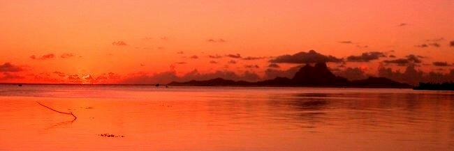
As usual we like to close our story with a sunset. This one was taken from a wonderful BBQ site on Motu Tau Tau off the NW coast of Tahaa, looking over the 20 miles to Bora Bora.
Where to next:-
By mid-October we will have moved down to southern Tonga and be ready to look for a weather slot to make the tricky 1000 mile crossing to New Zealand. The weather in the southern ocean as we head SW is unpredictable with severe gales that can develop suddenly. Once there, we will base ourselves in the Bay of Islands area in the north, maybe cruising as far south as Auckland. The plan is to buy a camper to tour by land also. We will be in those waters until around the end of May '03 when it will be time to head NE back to the Pacific islands, Fiji, New Caledonia, New Hebrides and maybe Tonga again.